


Results 1 to 3 of 3
Threaded View


-
10-16-2014, 09:37 AM #1Administrator

- Join Date
- Jan 2014
- Posts
- 7,697

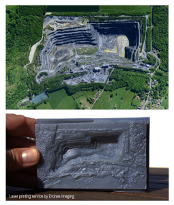
Drones Provide Data for 3D Printed Survey Models
France-based Drone Imaging is using drones, or UAVs (unmanned aerial vehicles), to produce 3D printed models of aerial geological and architectural surveys. Drones have been used in military and commercial capacities, and now are being used in the industrial sector where 3D printing has a critical role to play in realizing results. For more details on this innovative use of 3D printing, check out the following article: http://3dprint.com/18610/uavs-photogrammetry-3d-print/
Below is a picture of a 3D printed model produced via UAV imaging:


 Reply With Quote


Ender 3 Neo - Jam Problem
Yesterday, 03:06 PM in Tips, Tricks and Tech Help